NASA Earth Observatory Profiles Deep Meanders of Utah's San Juan River
Satellite observations from NASA highlight the intricate entrenched meanders of the San Juan River across southeastern Utah's arid terrain.
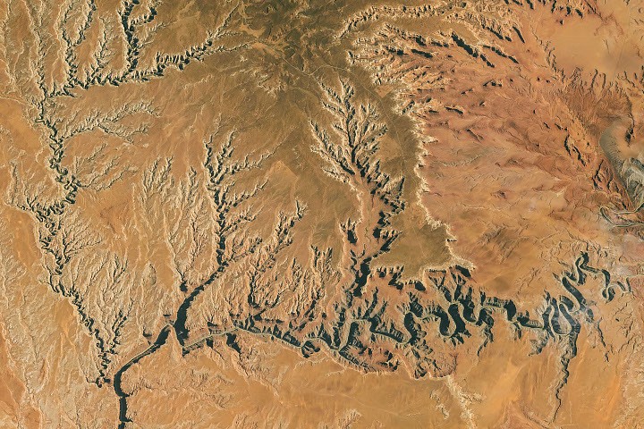
Satellite observations released by NASA News Releases through the NASA Earth Observatory highlight the Goosenecks of the San Juan River in southeastern Utah, where the waterway has carved deep, tightly curving meanders across the desert landscape. The space agency's remote sensing profile captures the stark geomorphic geometry of the river canyon, illustrating how long-term hydrological incision interacts with arid plateau geology to form one of North America's most pronounced entrenched river systems.
High-resolution orbital observation of terrestrial landforms serves as a foundational benchmark for planetary geology, hydrological modeling, and space-based environmental monitoring. By documenting how water shapes resistant rock formations on Earth over geological timescales, remote sensing platforms provide scientists and infrastructure planners with critical reference data for erosion dynamics, sediment transport, and comparative planetary surface analysis across the solar system.
Geological Context and Orbital Observation
According to NASA News Releases, the Goosenecks formation represents a classic example of entrenched river meanders, where the San Juan River winds through a series of tight, repetitive loops deep below the surrounding desert rim. Rather than shifting laterally across a broad floodplain, the river channel remains locked into its sinuous course while cutting vertically downward into the underlying sedimentary strata of the Colorado Plateau.
From an orbital vantage point, the sharp contrast between the shadowed canyon walls, the reflective river channel, and the surrounding arid terrain allows Earth-observing satellites to map the precise curvature and depth of the gorge. NASA's Earth Observatory program regularly utilizes multispectral and optical sensors aboard orbital platforms to document such distinct geological formations, creating a continuous visual and scientific archive of terrestrial surface evolution. Because the surrounding desert supports minimal vegetation cover, the exposed rock layers offer an unobstructed view for spaceborne instruments calibrating surface reflectance and topographic relief.
Technological and Scientific Impact in Remote Sensing
The ability to resolve intricate canyon systems like Utah's Goosenecks from low-Earth orbit underscores the analytical value of modern Earth observation architectures. Geological and hydrological researchers rely on orbital imagery to measure channel sinuosity, slope stability, and watershed drainage patterns across remote regions where ground-based surveying remains logistically complex and costly.
Beyond terrestrial resource management, terrestrial analogs of deep, winding channels play a direct role in astrobiological and planetary research. Planetary geologists frequently compare orbital imagery of entrenched terrestrial rivers with high-resolution surface scans of Mars and Saturn's moon Titan, where ancient or active fluid channels exhibit similar meandering geometries. By correlating known water flow rates, rock hardness, and incision depths along the San Juan River with remotely sensed spectral signatures, mission scientists refine the algorithms used to interpret paleoclimate histories on extraterrestrial bodies. Furthermore, civil engineering and environmental monitoring agencies utilize longitudinal satellite datasets of the Colorado River basin—of which the San Juan River is a major tributary—to track long-term water availability and reservoir sedimentation trends across the American Southwest.
Outlook for Spaceborne Landform and Hydrology Monitoring
As space agencies and commercial satellite operators deploy next-generation synthetic aperture radar, lidar, and hyperspectral imaging constellations, the precision of topographic and hydrological mapping across arid river basins is set to advance significantly. Future orbital missions will enable three-dimensional volumetric tracking of canyon erosion and seasonal water level fluctuations at sub-meter resolution.
Continued observation of benchmark geological sites like the Goosenecks of the San Juan River will remain essential for calibrating orbital sensors and validating surface-process models. By integrating historical imagery from NASA's Earth Observatory archive with emerging spaceborne telemetry, researchers will maintain a high-fidelity record of how climate variability and hydrological forces continue to reshape continental landscapes over both seasonal cycles and geological epochs.